datadista logo
ENVIRONMENT

The truth about the transfer

The water from the Tagus river did not arrive in the promised amount, but irrigation spread as if it had and beyond. The secret was beneath the ground, in the already overexploited aquifers. The CHS chose for decades to look the other way.

The water from the Tagus river did not arrive in the promised amount, but irrigation spread as if it had and beyond. The secret was beneath the ground, in the already overexploited aquifers. The CHS chose for decades to look the other way.

By Antonio Delgado and Ana Tudela

OCTOBER 2019

VERSIÓN EN ESPAÑOL
Entrepeñas reservoir (Guadalajara province) July 5th, 2017 / Ignacio López/JCCM

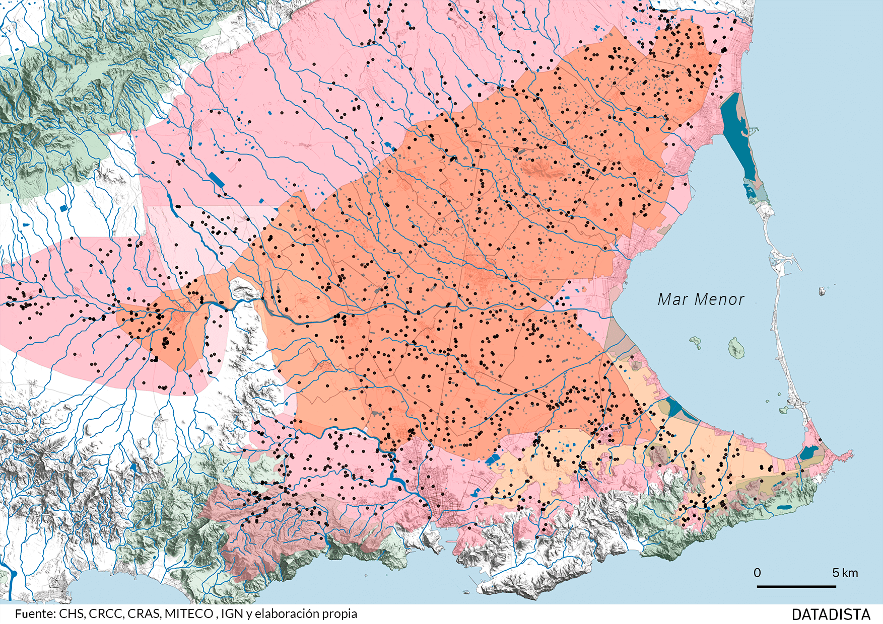
The soil in south-eastern Spain is tremendously fertile. It profits from every drop of water like no other soil in the country. But there's little water. Very little. The inhabitants of the Campo de Cartagena have spent more than a century looking for it literally under stones, first with their lateen sail mills and then, taking advantage of extraction machinery used in the nearby mining sites of the Sierra Minera, deeper and deeper. The result was so good that, when engineer Manuel Lorenzo Pardo visited the region, commissioned by Indalecio Prieto to draw up the National Plan for Hydraulic Works during the Second Republic (1933), he stated, upon returning to Madrid, that the Nile river would have to be taken there if necessary.

In a pragmatic rush, they opted for the Tagus. The Civil War and the black years of autarchy cut the plans short, so that the works on the Tagus-Segura Transfer (TTS) were not resumed until 1965, and the transfer only opened in 1979, forty years ago.

Turn it for a better view

From a civil engineering point of view, figures were dazzling. A 292-kilometre canal with a flow rate of up to 33 cubic meters per second. At its starting point, at the Bolarque reservoir, water is pumped to bridge the 245-meter difference in height, along a 1,070 meter span.

However, the really relevant figures, those of the water that was supposed to be sent from one basin to another, were not only not fulfilled.

The first phase of the Transfer involved "an annual maximum of 600 million cubic metres" that would be diverted from the Tagus River to the Segura. Of these, 400 were for irrigation, 110 for urban consumption and the rest, estimated evaporation.

The 400 million cubic meters of water for irrigation are distributed among the provinces of Murcia, Alicante and Almeria. Murcia was allocated the greatest annual amount: 260 million cubic meters. And within Murcia, the Association of Irrigators to which the largest volume was allocated was that of the Campo de Cartagena, with 122 hm³ per year. The second phase was never approved.

Total net consumption of the Tagus-Segura transfer, destined for irrigation per hydrological year. (*) Data up to July 2019, in hm³. | Source: Confederación Hidrográfica del Segura

The average amount of water transferred from the Tagus to the Segura since 1980 has been less than half the maximum foreseen. According to CHS figures, average irrigation resources from the transfer during the hydrological series 1980/81 - 2017/18 are quantified at 175 hm³/year (at destination point). That’s the medium of the long series. In recent years, when drought has returned, the transferred volume has been much lower.

Irrigation spread throughout the Segura basin and with it through the Campo de Cartagena as if the water from the Transfer had arrived in the expected quantity year after year.

As if there had not been intermittent but long drought periods that drastically reduced the volume transferred.

It wasn't very difficult to know where water for irrigation was drawn from. There is a hidden, parallel world to this transfer. There is another side of the story.

There is a gigantic root under the ground, from which most of the Campo de Cartagena actually drinks (up to 80% of the water in dry seasons), formed by wells, pipes and desalination plants. It has caused a natural disaster.

This situation has damaged the lagoon and has overexploited and polluted aquifers with nitrates from the fertilizers applied on intensively irrigated fields. A world beneath the furrows of iceberg lettuces, melons and lemon trees, a world that has furthermore a direct connection with the Mar Menor.

"When water from the transfer has been available, groundwater has covered 30 to 35 percent of the demand. But when no water from the transfer came, it was groundwater that covered up to 80 percent. (...) Groundwater is the key to the fact that it has at all been possible to maintain the system".

José Luis García Aróstegui, head scientist at IGME Murcia.

Groundwater in Spain is -in theory- protected since the 1985 Water Law was passed (29/1985 of August 2nd), classifying this resource as public property for the first time. Regulatory protection has also been strengthened at the European level, as groundwater is the future reserve from which communities will be supplied when climate change induces longer and more frequent drought periods.

-13.000 hm³
CONSUMED RESERVATIONS

The fact that more groundwater is being extracted from the aquifers of the Segura River Basin than nature is capable of replenishing is known since at least 1986, seven years after the Transfer provided its first deliveries.

On December 30th of that year, King Juan Carlos I interrupted his Christmas holidays to sign, from the ski resort of Baqueira-Beret, a Royal Decree Law that the socialist government of Felipe González considered "extremely urgent".

The Official State Gazette reported that "the studies carried out for the elaboration" of the Segura Basin Plan "made it possible to confirm the serious overexploitation of numerous aquifers". As the water level dropped, it was expected that "the interested parties" - the irrigators of the Segura River Basin - would look for "new supply sources, the immediate consequence of which will be the disorderly exploitation of the few underground resources that may still exist".

After Parliament endorsed the rule, the next step, set out both in the Law and in the regulations to implement it (849/1986 of April 11th), was clear.

In overexploited aquifers, an extraction management plan in order to reduce water withdrawals is required by law. Its formulation should have started in 1987. It's been 32 years.

"What the law dictates was not easy to accomplish if you wanted to maintain agricultural activity. (...) If you are extracting more water from an aquifer than from the renewable resource, the Management plan must try to lower the extraction rate. (...) That, since 1987, has not been done".

Mario Urrea, president of the Confederación Hidrográfica del Segura.

"The vast majority of aquifers are overexploited. (...) The figure that officially recognizes overexploitation is only provisional, so that is easy to avoid the obligation dictated by the Water Law to draw up a Management Plan for extractions".

Julia Martínez, ecologist and technical director of the Nueva Cultura del Agua Foundation.

"On an environmental level, the two main problems are the overexploitation of aquifers: we are talking about an emptying of the Segura Basin groundwater reserves probably exceeding 13,000 hm³. And the problem of the Mar Menor".

José Luis García Aróstegui, head scientist at IGME Murcia.

Captaciones vigentes en el Campo de Cartagena
An analysis made by DATADISTA on all digitalized current catchments on the Campo de Cartagena and Triassic de las Victorias aquifers, estimates that the more than 1,600 authorised wells and boreholes provide a maximum expected volume of around 110 hm³ per year. On top of the aquifers, the perimeters corresponding to the Associations of Irrigators Campo de Cartagena and Arco Sur are shown / CHS, CRCC, CRAS, MITECO, IGN and own elaboration.

¿How much water is pumped in this area? It's the million-dollar question that not even CHS can entirely answer. There is no quantification of direct meter readings, nor is there digitization of all current rights, which is decades overdue.

I remember a conversation with a director of the CHS who asked me: what needs to be done so that the wells stop drawing water? —You give me six cubic meters per second on the channel and tomorrow they're all stopped".

Manuel Martínez, President of the Campo de Cartagena Association of Irrigators.

"There is an enormous lack of knowledge about the proportion of illegal wells or catchments. As flowmeters are lacking , we do not know how much water they are catching. Above all, because of their nature: irregular, not communicated, not authorized and therefore not granted"

Julia Martínez, ecologist and technical director of the Nueva Cultura del Agua Foundation.

"A general hydrogeological study of the entire Campo de Cartagena is needed. Among the first activities or tasks required are the inventory of water points and a quantification of extraction through pumping. That is key because there's uncertainty about how much is actually being pumped and from which aquifer it is being extracted".

José Luis García Aróstegui, head scientist at IGME Murcia.

There is a document that proves how uncontrolled the situation was after decades of allowing the irrigators to do as they pleased. After the changing of the CHS presidency in 2012 and especially after the appointment of José Carlos González as Water Commissioner, the CHS tendered a technical study (file number 03.0005.13.006) to help irrigators regularize existing water uses that had not yet been registered.

In the Terms of Reference, signed by the water commissioner (2012-2018), the CHS recognizes that it is incapable of managing what it does not know. The vast majority of irrigable land rights applied for before 2002 lack information. In many cases they were processed with a simple sketch. In many others, without even defining the irrigable areas. The CHS even acknowledges that in a dozen cases "practically everything is unknown".

expediente 2012

"Es una evidencia manifiesta que el principal requisito previo a una correcta gestión de las aguas en una cuenca tan compleja como la del Segura es tener registrados y perfectamente definidos todos los derechos: no se puede gestionar lo que no se conoce."

(...) "La gran mayoría de ellos (prácticamente, todos los anteriores al 2002) fueron tramitados por una Administración carente de medios técnicos modernos, con lo que especialmente el elemento cartográfico de las concesiones y derechos (en claro: las superficies regables) estaba definida mediante poco más que simples croquis, cuando no era totalmente inexistente".

(...) "Este inexacto o inexistente conocimiento ha dado lugar a confusiones, inscripciones duplicadas y, en general, a todo tipo de problemas."

The regulations to implement the Water Law did not only oblige to regulate extraction in cases of aquifer overexploitation or risk thereof. It also implied "fully halting all requests for the authorization of new water concessions" in overexploited aquifers.

Spanish administrations opted to slow down the bureaucratic machine to its minimum speed until it almost stopped and, in the meantime, laisser faire.

Not having a registered license did not oblige anyone to stop extracting water. Chaos spread through the Campo de Cartagena.

Current president of the Confederación Hidrográfica del Segura, Mario Urrea, in an exclusive interview with DATADISTA, not only acknowledges that since 1987 no plans have been made to reduce extractions as mandated by law, but that now that an alternative resource is available, licenses are being formalized in farms that for decades were allowed to make use of groundwater from overexploited aquifers. He acknowledges that this is illegal but calls it "illegal with an asterisk", because the law, itself allowed for shortcuts to regularize irrigation that had continued to spread although it should have been forbidden already in 1986. .

"We cannot regularize irrigation with water from the basin itself (...) We are now handling a very large volume of desalinated water. Well, it is on those desalinated waters that we can regularize the irrigation operations that started before 1998 (...) We are regularizing quite a lot of those areas that are detected but not officially registered."

Mario Urrea, president of the Confederación Hidrográfica del Segura.

Public administration opted to find possibilities operable within the basin plans to regularize the irrigation operations that had been spreading before their eyes uncontrolled, and despite the fact that they was prohibited by the Water Law.

As proof, three days after the approval of the 2009-2015 Hydrological Plan, the CHS signed the Terms of Reference for the tender for a technical service to help them regularize pending hydraulic developments. It reflects the intention to "open a door for the regularization of irrigation operations existing since before 1998," which "there are good reasons to assume, will be many.”

expediente 2014

(..) existen razones fundadas para suponer que van a ser muchos los que se acojan a este precepto, ya que también son muchos los que se encuentran en esta situación, y que han visto como sus peticiones de regularización e inscripción en base a las Disposiciones Transitorias de la Ley de Aguas han sido rechazadas al no haberse considerado acreditada la existencia del aprovechamiento el 1 de enero de 1986, acreditación por la que la jurisprudencia ha ido endureciendo paulatinamente los requisitos de prueba documental."

expediente 2014

"La nueva normativa, al establecer una fecha tan cercana (1998) como fecha de acreditación de la existencia del aprovechamiento, facilita tal acreditación y constituye el último cartucho que estos aprovechamientos pueden usar para pretender a esa tan deseada regularización.

"Es evidente que no puede repetirse la experiencia habida con las inscripciones de derechos en base a las Disposiciones Transitorias de la Ley de Aguas, donde después de 25 años de tramitaciones quedan aún abiertos numerosos expedientes pendientes de resolución, retraso que no ha hecho sino aumentar las dificultades de acreditación, de existencia, características y aforo."

They called irrigation developments established before 1998 consolidated irrigation, a figure that only exists in the Segura Basin. And this invention was justified by conditioning the formalization only to cases where groundwater "at risk of not achieving good quantitative or chemical status, or in its case of overexploitation" would not be affected.

In other words, there was no room for regularization unless it was "with new external resources", i.e. "any resource coming from hydrographic basins other than that of the Segura" or "desalinated resources coming from seawater". The same happened with the UDA (Unidades de Demanda Agraria – Agricultural Demand Units), perimeters not associated to a legal entity but within which the CHS has considered that concessions can be formalized.

In 2018, WWF and ANSE published an analysis of the evolution of irrigation in the Mar Menor area. This work, built on the analysis of satellite images, Sigpac and field work, determined that irrigation has multiplied tenfold between 1977 and 2017..

Nearly 25% of the irrigated surface falls outside the limits authorized by the CHS. This means that, according to the WWF and ANSE study, 12,165.18 hectares or irrigated agriculture are illegal.

Faced with the impossibility of licensing extractions from over-exploited aquifers, the CHS used the basin plans to exercise a kind of lobby, repeatedly asking not only for new external resources to sustain agriculture but also for them to be cheap - something that, in their opinion, desalinated seawater did not comply with- , in order to maintain agricultural profitability. It is important to note that more than 80% of the water demands made to the CHS are for agricultural activities.

A new transfer from other basins came close to being achieved. The National Hydrological Plan of 2001, approved when the Popular Party occupied the central Government, included the transfer from the Ebro river to the Segura basin. Four years later, already with the PSOE in the National Government, the 2005 National Hydrological Plan cancelled the Ebro transfer plans, placing the focus on creating new flows through sea water desalination.

The strategy had an expiration date. The laxity of the Spanish authorities clashed with a reality: The European Union. The Water Framework Directive does not allow groundwater to maintain a state of overexploitation beyond 2027, so that in the first documents drafted for the basin plan currently under preparation, there is no longer any mention of resources from other basins and it is admitted that it will be the desalination of seawater that replaces groundwater. Irrigators question whether this is feasible.

This uncontrolled use of the aquifer is further heightened by the operation of illegal wells, the number of which is also unknown. In 2016, the CHS placed the number somewhere between one and two thousand.

Illegal water extraction is punishable under article 247 of the Spanish Criminal Code and is also an administrative offence according to the Water Law, but insufficient information and field inspections have made it impossible for the Attorney General's Office to pursue action, until very few years ago.

Adding to this situation is the fact that, in periods of drought, the opening of new boreholes, known as drought wells, was authorised. According to the law, their use should cease as soon as the scarcity period ended. This did not happen.

‹‹ Home | Secrets of the polluted aquifer ››